

Featured categories
Auctions ending soon
See all
1910 Plat Map ~ DEER CREEK Twp., TAZEWELL Co., Illinois (15x17)-#004
C $46.770 bids1m
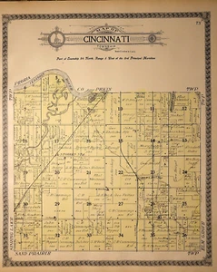
1910 Plat Map ~ CINCINNATI Twp., TAZEWELL Co., Illinois (15x17)-#005
C $46.770 bids3m
1910 Plat Map ~ ELM GROVE Twp., TAZEWELL Co., Illinois (15x17)-#006
C $46.770 bids5m
1910 Plat Map ~ TREMONT Twp., TAZEWELL Co., Illinois (15x17)-#007
C $46.770 bids7m
1910 Plat Map ~ MACKINAW Twp., TAZEWELL Co., Illinois (15x17)-#008
C $46.770 bids10m
1910 Plat Map ~ SAND PRAIRIE Twp., TAZEWELL Co., Illinois (15x17)-#009
C $46.770 bids12m
All items

1910 Plat Map MINER, CIRCLEVILLE, WINKEL, LILLY, TAZEWELL Co., IL (XL17x29)-#020
C $46.770 bids44m
1910 Plat Map ~ CINCINNATI Twp., TAZEWELL Co., Illinois (15x17)-#005
C $46.770 bids3m

1910 Plat Map ~ EAST PART of EAST PEORIA, TAZEWELL Co., IL (XL17x29)-#022
C $46.770 bids49m

1910 Plat Map ~ SOUTH PART of PEKIN, TAZEWELL Co., Illinois (XL17x29)-#019
C $46.770 bids40m

1910 Plat Map ~ MACKINAW Twp., TAZEWELL Co., Illinois (15x17)-#008
C $46.770 bids10m

1910 Plat Map ~ ELM GROVE Twp., TAZEWELL Co., Illinois (15x17)-#006
C $46.770 bids5m

1910 Plat Map ~ ARMINGTON, TAZEWELL Co., ILLINOIS (9.5x17)-#029
C $38.520 bids1h 11m

1910 Plat Map ~ TREMONT Twp., TAZEWELL Co., Illinois (15x17)-#007
C $46.770 bids7m

1910 Plat Map ~ SAND PRAIRIE Twp., TAZEWELL Co., Illinois (15x17)-#009
C $46.770 bids12m

1910 Plat Map ~ DEER CREEK Twp., TAZEWELL Co., Illinois (15x17)-#004
C $46.770 bids1m

1910 Plat Map ~ HOPEDALE Twp., TAZEWELL Co., Illinois (15x17)-#011
C $46.770 bids17m

1910 Plat Map ~ LITTLE MACKINAW Twp., TAZEWELL Co., Illinois (15x17)-#012
C $46.770 bids20m

1910 Plat Map ~ DILLON Twp., TAZEWELL Co., Illinois (15x17)-#010
C $46.770 bids15m

1910 Plat Map ~ MACKINAW Twp., TAZEWELL Co., ILLINOIS (18x17)-#037
C $46.770 bids1h 31m

1865 Map ~ TEXAS ~ Authentic Johnson Atlas Map (18x27)-#008 (AS-IS)
C $49.525 bids1d 21h 59m

1889 Map ~ CHICAGO, IL ~ (12x17) ~ Good Condition ~ Free S&H-#044
C $31.47

1910 Plat Map ~ CLOVERDALE, TAZEWELL Co., ILLINOIS (9.5x17)-#025
C $38.520 bids1h 5m

1910 Plat Map ~ DELAVAN Twp., TAZEWELL Co., Illinois (15x17)-#014
C $46.770 bids26m

1910 Plat Map ~ BOYNTON Twp., TAZEWELL Co., Illinois (15x17)-#015
C $46.770 bids28m

1910 Plat Map ~ GROVELAND - GREEN VALLEY, TAZEWELL Co., ILLINOIS (11.5x17)-#031
C $38.520 bids1h 16m

1910 Plat Map ~ MALONE Twp., TAZEWELL Co., Illinois (15x17)-#013
C $46.770 bids23m

1894 Plat Map ~ KENNEY Twp., DeWitt Co., ILLINOIS (15x17)-#002
C $67.24

1847 Map ~ EARLY UNITED STATES - NORTH MID-WEST TERRITORIES -#002
C $49.523 bids2d 23h 0m

Nice 1888 R McNally Atlas Map ~ ALABAMA ~(LG14x20) ~Free S&H ~Inv#197
C $24.760 bids21h 48m

1959 Picture / Pictorial Map Geography of ARIZONA by PS JOHST - VERNON QUINN
C $24.760 bids23h 47m

1910 Plat Map ~ SOUTHEAST PART of PEKIN, TAZEWELL Co., Illinois (15x17)-#017
C $46.770 bids34m

1910 Plat Map ~ HITTLE Twp., TAZEWELL Co., Illinois (15x17)-#016
C $46.770 bids31m

1910 Plat Map ~ WEST PART of EAST PEORIA, TAZEWELL Co., IL (XL17x29)-#021
C $46.770 bids47m

1910 Plat Map ~ NORTH PART of PEKIN, TAZEWELL Co., Illinois (XL17x29)-#018
C $46.770 bids38m

1910 Plat Map ~ DELAVAN Twp., TAZEWELL Co., ILLINOIS (19x17)-#035
C $46.770 bids1h 26m

1873 Plat Map ~ NORTH Ave. - HARVEY & TANNERY St. - CAMBRIDGE, MA (14x17)-#002
C $121.050 bids2d 3h 56m

1875 Map ~ The CITY of CHICAGO, ILLINOIS (15x18)-#015
C $46.771 bid4d 3h 3m

Authentic 1928 Pictorial Map by L. Price ~ A FANTASIE MAP - COMPASS, CASTLES
C $24.760 bids22h 57m

1910 Plat Map ~ CRANDALL - HOPEDALE, TAZEWELL Co., ILLINOIS (11x17)-#024
C $38.520 bids1h 1m

Rare 1852 Map ~ CENTRAL AMERICA - WEST INDIES, JAMAICA ~ (9.5x12) #P280
C $31.47

1847 Map ~ NEW YORK STATE - LONG ISLAND - LAKE ONTARIO (14x17) Free S&H-#006
C $46.771 bid2d 22h 58m

1825 Map ~ NORTH AMERICA, MEXICO incl. TEXAS - EARLY AMERICA - RUSSIAN AMERICA
C $67.24

1938 Colorful Pictorial Map ~ MASSACHUSETTS by Norman Reeves ~ 1939 World's Fair
C $24.760 bids23h 1m

1959 Picture / Pictorial Map Geography of OREGON by PS JOHST - VERNON QUINN
C $24.761 bid23h 39m

1831 Map ~ PACIFIC OCEAN - NEW HOLLAND - SANDWICH ISLANDS ~ (9x12) #P277
C $31.47

1910 Plat Map ~ STATE of ILLINOIS - CHICAGO (17x29)-#040
C $33.010 bids1h 44m

1875 Map ~ THE WEST INDIES / CARIBBEAN (15x18)-#028
C $46.770 bids4d 4h 29m

Old 1849 Authentic Mitchell Atlas Map ~ HEMISPHERES of the WORLD ~ Free S&H
C $30.26

1874 Plat Map ~ CANANDAIGUA, ONTARIO Co., NY (15x23) #009
C $93.540 bids3d 1h 47m

1865 Map NEBRASKA, COLORADO, MONTANA TERRITORIES, Johnson Atlas Map (14x18)#004
C $66.030 bids1d 4h 9m

1910 Plat / County Map ~ TAZEWELL County, ILLINOIS (15x17)-#039
C $46.770 bids1h 37m

1874 Plat Map ~ CANANDAIGUA, CHESHIRE, CENTERFIELD, ONTARIO Co., NY (15x23) #010
C $94.912 bids3d 1h 51m

1938 Colorful Pictorial Map ~ VERMONT by Norman Reeves for 1939 World's Fair
C $24.760 bids22h 14m
About us
Welcome to my eBay Store. Please add me to your list of favorite sellers and visit often. Thank you for your business.
Store policies
Shipping
Seller feedback (8,778)
k***3 (4053)- Feedback left by buyer.
Past 6 months
Verified purchase
Quick Shipping-Great Communication-Item arrived as described and well packaged-Very Pleased with seller-Recommended-A+++
k***3 (4053)- Feedback left by buyer.
Past 6 months
Verified purchase
Quick Shipping-Great Communication-Item arrived as described and well packaged-Very Pleased with seller-Recommended-A+++
t***m (27)- Feedback left by buyer.
Past 6 months
Verified purchase
Item was as pictured and described. Packaged well. Shipped reasonably fast enough. Was originally shipped the wrong thing but the seller made it right. I definitely recommend this seller. A+++
e***i (94)- Feedback left by buyer.
Past 6 months
Verified purchase
Another great order from this seller. Super fast shipping and shipping packaging materials ensure the item arrived without damage. Item exactly as described and as in photos. Will continue to do business with this A+++++++ seller and purveyor of maps!
a***o (38)- Feedback left by buyer.
Past month
Verified purchase
Accurately described, well packaged, really nice vintage map. I'd buy from this vendor again. My only feedback for the vendor -- it is cut out of an atlas (standard for this kind of map) and it came with a BEAUTIFUL map of Sacramento printed on the back; I didn't see any indication of the back details, but I'm treating that as a nice bonus instead of an issue.
c***r (2972)- Feedback left by buyer.
Past 6 months
Verified purchase
Great Transaction!
Item as described.
Fast shipping and Well packed!
Highly Recommend AAA+++!